


Weather Forecasting at a Glance: What You Need to Know
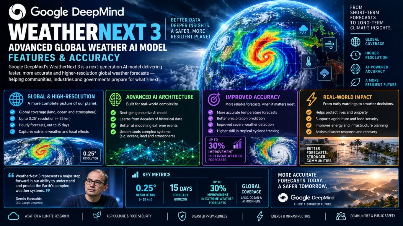
- WeatherNext 3 is Google DeepMind’s most advanced global weather AI model, ranked #1 for accuracy by independent live evaluations from Brightband.
- Unlike every previous AI weather model, WeatherNext 3 learns directly from real-world satellite and ground station data — not from physics-based simulations.
- It produces forecasts at 0.05° (5 km) spatial resolution with hourly updates, making it five times sharper than its predecessor, WeatherNext 2.
- WeatherNext 3 is already embedded into Google Search, Google Maps, and Gemini — meaning millions of people are using it right now without knowing it.
- Keep reading to find out how the model bypasses a critical 6-hour data lag that has plagued traditional forecasting for decades — and why that changes everything for storm prediction.
Weather forecasting just crossed a threshold that scientists have been chasing for generations — and it happened quietly inside a Google lab.
Google DeepMind and Google Research have jointly released WeatherNext 3, a global weather AI model that doesn’t just improve on existing technology — it rethinks the entire foundation of how forecasts are built. Whether you’re a storm chaser, a farmer watching a frost window, or someone who just wants to know if Saturday’s picnic is safe, this model changes what’s possible. For anyone who takes weather seriously, Google’s Weather Lab lets you explore WeatherNext 3 visualized in real-time — and it’s genuinely worth the visit.
WeatherNext 3 Is the Most Accurate Global Weather AI Model Available Today
WeatherNext 3 is the current benchmark for global weather forecasting accuracy. It was developed collaboratively by Google DeepMind and Google Research, combining cutting-edge machine learning architecture with live observational data streams that no previous weather AI has used as a direct training input. The result is a model that doesn’t just predict the weather — it understands it at a level of granularity that was simply out of reach before.
Developed by Google DeepMind and Google Research
This isn’t a single team’s project — it’s the product of two of the most powerful AI and scientific research organizations in the world working in tandem. Google DeepMind brought the deep learning architecture expertise, while Google Research contributed the observational data pipelines and training methodology. Together, they built something that outperforms both traditional numerical models and every prior AI weather system in head-to-head evaluations.
Ranked #1 by Independent Live Evaluations from Brightband
Independent validation matters in science, and WeatherNext 3 earned its ranking the hard way. According to live evaluations conducted by Brightband, an independent weather model benchmarking organization, WeatherNext 3 leads all global weather models currently available. These aren’t cherry-picked retrospective tests — they are ongoing, live comparisons run against real-world outcomes as forecasts verify.
That kind of third-party confirmation carries significant weight. It means the model’s performance isn’t a controlled-environment result. It holds up when the actual atmosphere does what it does: surprise everyone.
Now Powering Weather Forecasts Across Google Search, Maps, and Gemini
WeatherNext 3 isn’t sitting in a research paper waiting to be deployed. It’s already live. Google has integrated the model directly into Google Search, Google Maps, and Gemini, meaning the forecast you check before leaving the house is now being driven by the most accurate global weather AI ever built. For developers and enterprises, the model is also accessible via Google Cloud and the WeatherNext developer platform.
The scale of that deployment is staggering. Billions of weather queries pass through Google Search every year. WeatherNext 3 is now answering them with hourly, high-resolution data that previous models simply couldn’t provide.
What Makes WeatherNext 3 Different From Every Other Weather Model
The core innovation isn’t just better hardware or more data — it’s a fundamentally different philosophy about where a weather model should learn from.
Trained on Real-World Observations, Not Physics Simulations
Every major AI weather model before WeatherNext 3 — including WeatherNext 2 — was trained on data generated by Numerical Weather Prediction (NWP) models. NWP models are sophisticated physics-based simulations that run on supercomputers. They’re incredibly detailed, but they are still simulations. You’re training an AI on another model’s output, which means you inherit every bias, smoothing error, and structural limitation built into that simulation.
WeatherNext 3 breaks that chain entirely. It trains directly on real-world observational data: live geostationary satellite feeds and sparse surface weather station measurements from actual ground-level sensors around the globe. There’s no simulation layer in between. The model learns what the atmosphere actually does, not what a physics engine predicts it should do.
“WeatherNext 3 trains directly on real-world weather station observation data, allowing it to make global forecasts on a 5-kilometer grid that account for regional details like topography.”
— Google DeepMind, WeatherNext 3 Official Announcement
Why Traditional Numerical Weather Prediction Models Fall Short
NWP models have been the backbone of global forecasting for decades, and they’ve done remarkable work. But they carry structural limitations that even the best computational resources can’t fully overcome, as highlighted in the latest AI news updates.
- They require supercomputers to run physics simulations that take hours to complete, creating built-in delays before a forecast is even issued.
- Data assimilation takes time. Observational inputs must be collected, processed, and ingested into the model — a process that introduces a lag of up to six hours before the model even starts generating output.
- Resolution is limited by computational cost. Running a global physics simulation at fine spatial scales is extraordinarily expensive, so most operational NWP models operate at coarser resolutions than what local forecasting actually needs.
- Smoothing errors accumulate. Because NWP models simplify physical processes to make computation tractable, small errors compound over time, degrading forecast skill at longer lead times.
- They struggle with surface-level detail. Capturing the influence of local terrain, coastlines, and vegetation on near-surface temperature and precipitation requires resolution that NWP systems rarely achieve in real-time operational settings.
These aren’t criticisms of effort — they are hard physical and computational constraints. WeatherNext 3 sidesteps many of them by replacing the simulation pipeline with direct observational learning.
How Bypassing the 6-Hour NWP Data Lag Changes Everything
Here’s the problem with the traditional forecasting pipeline in plain terms: by the time an NWP model finishes collecting observations, running its simulation, and producing a forecast, the atmosphere has already moved on. That 6-hour lag is a structural feature of how numerical models operate, and for fast-moving weather systems — think rapidly intensifying storms, flash flood events, or sudden wind shifts — six hours is an eternity.
WeatherNext 3 is initialized every hour using live geostationary satellite observations fed directly into the model as inputs. There’s no waiting for a supercomputer to finish a physics run. The model ingests current satellite data and generates an updated forecast immediately, keeping pace with the atmosphere in a way that traditional NWP systems structurally cannot.
For severe weather applications, that difference is not marginal — it’s the difference between a warning issued with time to act and one issued after the fact. For insights into how technology is evolving to address these challenges, explore the latest trends in AI industry news.
| Feature | Traditional NWP Models | WeatherNext 3 |
|---|---|---|
| Training Data Source | Physics-based simulations | Real-world satellite & station observations |
| Update Frequency | Every 6+ hours | Every 1 hour |
| Spatial Resolution | Varies, typically 9–25 km | Up to 0.05° (5 km) |
| Supercomputer Required | Yes | No |
| Local Topography Capture | Limited | Yes, at 5 km grid scale |
WeatherNext 3 Spatial Resolution: 5x Sharper Than Its Predecessor
Resolution in weather modeling isn’t just a technical specification — it’s the difference between a forecast that tells you it will rain somewhere in your county and one that tells you the storm will hit your neighborhood at 3:00 PM. WeatherNext 3 produces forecasts at up to 0.05° spatial resolution, which translates to approximately a 5-kilometer grid. That’s five times finer than WeatherNext 2, which operated at a 0.25° (25 km) resolution.
WeatherNext 2 vs. WeatherNext 3 Resolution Comparison (25 km vs. 5 km)
To put those numbers in perspective: a 25 km grid box covers an area roughly the size of a mid-sized city and its surrounding suburbs as a single data point. Everything inside that box gets the same forecast value. At 5 km resolution, that same area is broken into 25 individual grid cells, each with its own forecast values shaped by local terrain, land cover, and atmospheric conditions.
For a mountain valley, a coastal zone, or any landscape with complex topography, that distinction is transformative. WeatherNext 3 maintains physical consistency from broad global wind patterns all the way down to local topography, something no previous global AI weather model has achieved at this scale and update frequency simultaneously. Learn more about the latest advancements in AI technology with AI news updates.
How 0.05° Resolution Captures Local Topography and Microclimates
A mountain range doesn’t care about grid boxes. When a storm system pushes moist air up a windward slope, precipitation intensifies sharply — then drops just as sharply on the leeward side. That rain shadow effect plays out over just a few kilometers, and at 25 km resolution, it disappears entirely into an averaged value that serves no one accurately. At 5 km, WeatherNext 3 resolves it.
The same principle applies to coastal zones where sea breezes develop, urban heat islands where temperature can differ by several degrees from surrounding rural areas, and valley floors where cold air pools overnight. These aren’t edge cases — they’re the conditions where forecast accuracy matters most, and where traditional global models have consistently underperformed. WeatherNext 3’s 0.05° grid captures the atmospheric fingerprint of terrain in a way that finally makes global AI forecasting genuinely useful at the local level.
Crucially, this isn’t just about sharper numbers on a map. The model maintains physical consistency across scales, meaning the fine-resolution surface detail it resolves connects coherently to the large-scale atmospheric patterns driving it. You get local precision without sacrificing the global picture.
How WeatherNext 3 Uses Live Satellite Data
The most radical architectural decision in WeatherNext 3 is also the simplest to explain: instead of waiting for processed, simulated data to arrive, the model looks out the window. Live geostationary satellite observations feed directly into the model as raw inputs, giving WeatherNext 3 something no previous global weather AI has had — a continuous, real-time view of the atmosphere as it actually is right now.
Geostationary Satellite Observations as a Direct Model Input
Geostationary satellites orbit at approximately 35,786 kilometers above the equator, maintaining a fixed position relative to Earth’s surface. That fixed vantage point means they capture continuous imagery of the same region every few minutes, tracking cloud development, moisture movement, and storm organization in near real-time. Previous AI weather models used this data only indirectly, after it had been filtered through an NWP assimilation process. WeatherNext 3 ingests it directly.
By making live satellite imagery a first-class input rather than a pre-processed secondary source, WeatherNext 3 eliminates a significant layer of information loss. The model sees convective development as it happens — the early organizational signatures of thunderstorm clusters, the rapid deepening of tropical systems, the subtle moisture gradients that determine where a precipitation boundary will set up. That direct satellite connection is what enables hourly initialization at global scale.
Why Hourly Initialization Matters for Fast-Moving Weather Events
Weather doesn’t wait for model cycles. A squall line can travel 50 kilometers in an hour. A coastal fog bank can advance and retreat multiple times between the morning and afternoon commute. A rapidly intensifying tropical cyclone can jump a full intensity category in less time than it takes a traditional NWP model to complete its next run. Hourly initialization means WeatherNext 3 is never more than 60 minutes behind the current state of the atmosphere — a massive operational advantage over systems that update every 6 to 12 hours.
For emergency management, aviation routing, maritime operations, and severe weather warning systems, that responsiveness translates directly into lead time. More lead time means more preparation. In high-impact weather situations, every additional hour of accurate warning can be the difference between an orderly evacuation and a crisis response.
How Real-Time Ground Station Data Improves Surface Accuracy
Satellites see the atmosphere from above, but what happens at ground level is shaped by factors that satellite imagery alone can’t fully resolve — soil moisture, vegetation type, surface roughness, local terrain features. WeatherNext 3 addresses this by training directly on sparse weather station observation data collected from surface sensors distributed across the globe. These stations measure temperature, humidity, wind speed and direction, pressure, and precipitation at ground level, providing the surface truth that anchors the model’s near-surface forecast accuracy.
The word “sparse” here is important. Weather stations aren’t uniformly distributed — they’re dense over populated land areas and nearly absent over oceans, remote terrain, and developing regions. WeatherNext 3’s architecture is designed to extract maximum signal from this uneven distribution, learning to generalize accurate surface forecasts even in areas where station coverage is thin. That capability directly improves temperature and wind forecasts at the exact level where people actually experience the weather.
Rain and Snow Prediction Improvements Explained
Precipitation forecasting has always been the hardest problem in operational meteorology — small errors in temperature, moisture, and vertical motion compound into large errors in where, when, and how much rain or snow falls. By training on real observational data rather than NWP output, WeatherNext 3 avoids inheriting the systematic precipitation biases that have plagued AI weather models since their inception. The 5 km grid resolution also means the model can distinguish precipitation gradients that occur across short distances, such as the sharp boundary between heavy lake-effect snow and clear skies just downwind of a Great Lake, with a level of precision that directly improves forecast usefulness at the local level.
Who Benefits Most From WeatherNext 3 Forecasts
The improvements WeatherNext 3 delivers aren’t abstract — they translate into real decisions made better, across industries and everyday life. Here’s where the impact lands hardest:
- Farmers and agricultural operations tracking frost risk windows, irrigation timing, and harvest conditions at field scale
- Renewable energy operators managing solar and wind output forecasts for grid balancing and energy trading
- Emergency managers coordinating evacuation and resource pre-positioning ahead of severe weather events
- Aviation and maritime industries routing around hazardous conditions with greater confidence and precision
- Outdoor event planners and sports organizations making high-stakes scheduling decisions based on narrow weather windows
- Individual users who want to know not just whether it will rain, but exactly when and where within their local area
The common thread across all of these use cases is the same: they all require local accuracy and timely updates, which is precisely what WeatherNext 3 is engineered to deliver. A 25 km forecast is operationally useless for field-level agriculture or neighborhood-scale emergency planning. A 5 km hourly forecast is not.
It’s also worth noting that access isn’t restricted to large organizations with technical teams. Because WeatherNext 3 is already embedded in Google Search and Google Maps, the most accurate global weather AI model ever built is available to anyone with a smartphone right now, with no setup required.
Agriculture: Smarter Planting and Harvest Decisions
A late frost that arrives six hours earlier than forecast can wipe out an entire season’s worth of tender crop growth in a single night. For growers, the precision gap between a 25 km forecast and a 5 km hourly update isn’t a technical curiosity — it’s a financial survival issue. WeatherNext 3’s ability to resolve local terrain effects means valley floor frost risk can now be distinguished from ridge-top conditions within the same farm, enabling targeted protective action rather than field-wide guesswork. Combine that with hourly initialization and the result is a forecast tool that finally matches the temporal resolution that agricultural decision-making actually requires.
Renewable Energy: More Reliable Solar and Wind Output Predictions
Grid operators managing solar and wind assets live or die by forecast accuracy. Overestimate solar output on a cloudy day and you’re scrambling for backup generation. Underestimate wind speed and you’ve left clean energy capacity on the table while burning more expensive dispatchable power. The financial stakes in energy forecasting run into the millions of dollars per percentage point of forecast error, which is why the renewable energy sector has been one of the most aggressive early adopters of AI weather modeling.
WeatherNext 3’s 5 km resolution and hourly updates directly address the two biggest pain points in energy forecasting: the spatial mismatch between coarse model grids and the precise location of solar arrays and wind turbines, and the temporal lag that leaves grid operators blind to rapidly evolving cloud cover or wind ramp events. Both problems get substantially better with WeatherNext 3.
Why energy forecasters care about 5 km resolution: A single large wind farm may span terrain with significant elevation changes across just 10–15 km. At 25 km resolution, that entire farm gets one wind speed value. At 5 km, it gets three or more distinct values that reflect the actual variation in output across the installation — dramatically improving dispatch planning and grid balancing accuracy.
For solar operators, the model’s improved cloud detection and precipitation forecasting translates into better irradiance predictions, particularly around the rapid cloud development that can cut solar output by 70–80% within minutes on a convective afternoon. That kind of short-fuse accuracy is where WeatherNext 3’s real-time satellite ingestion makes the most immediate difference.
Everyday Planning: What Better Hourly Forecasts Mean for You
The practical difference WeatherNext 3 makes for daily decisions:
“Will it rain during my afternoon run?” — A 6-hour updated model gives you a probability for a 25 km zone. WeatherNext 3 gives you an hourly, neighborhood-scale answer updated 60 minutes ago.
“Is the storm going to hit before or after the outdoor wedding?” — Hourly initialization means the latest satellite-observed storm motion is already baked into the forecast, not data that’s 5 hours old.
“Do I need to bring the car in tonight?” — 5 km resolution means the model distinguishes your valley from the ridge three kilometers away, where the hail risk is entirely different.
The improvements in WeatherNext 3 don’t just serve enterprise users and government agencies. They show up in the weather widget on your phone, in the forecast card on Google Search, and in the route alerts on Google Maps. The accuracy upgrade is quiet and invisible by design — but it’s real, and it’s already there every time you check the weather before stepping outside.
For weather enthusiasts specifically, this is a genuine milestone. The kind of forecast resolution and update frequency that used to require specialized access to research-grade modeling tools is now embedded in the most widely used consumer products on the planet. That democratization of high-resolution forecasting is, in itself, a significant development in the history of meteorology.
How to Access WeatherNext 3 Data Right Now
Getting your hands on WeatherNext 3 data is far easier than you might expect from a model of this technical sophistication. Google has deliberately built multiple access pathways — one that requires zero technical knowledge and another that gives developers and enterprises direct programmatic control over the full dataset. Whether you’re a curious weather enthusiast or a data scientist building a commercial forecasting application, there’s an entry point designed for you. For those interested in the latest AI industry news and updates, there are plenty of resources available to keep you informed.
The simplest path requires nothing more than opening a browser. If you want to go deeper, Google’s Weather Lab offers a real-time interactive visualization of WeatherNext 3 output, letting you explore the model’s global forecasts across variables, altitudes, and time steps in a way that makes the model’s resolution and detail immediately tangible. For anyone who loves weather data, it’s genuinely compelling to watch.
Built Into Google Search and Google Maps
WeatherNext 3 is already the engine powering weather forecasts in Google Search and Google Maps — two products that collectively handle billions of weather-related queries every year. When you search “weather today” or tap the forecast card in Google Maps before a road trip, the hourly, high-resolution output you’re seeing is WeatherNext 3 at work. No account required, no API key, no configuration. The most advanced global weather AI model ever built is already in your pocket.
Available via Google Cloud for Developers and Enterprises
For those who need raw data access, Google has made WeatherNext 3 available through the WeatherNext developer platform on Google Cloud. Developers can query forecast data programmatically, access multiple spatial resolutions, and integrate WeatherNext 3 output directly into their own applications, dashboards, and decision-support systems. Enterprises in agriculture, energy, logistics, and insurance are already building on top of this foundation — and with the model’s 5 km resolution and hourly update cadence, the commercial use cases are expanding rapidly. The expansion of big tech AI data centers is also contributing to the growing capabilities of platforms like WeatherNext 3. The full technical paper is also publicly available for those who want to understand the architecture at a deeper level.
WeatherNext 3 Signals a Permanent Shift in Global Forecasting
WeatherNext 3 isn’t an incremental update — it’s a structural break from everything that came before it. By learning directly from live satellite observations and real-world ground station data instead of physics simulations, it has severed the dependency on numerical weather prediction models that has constrained AI forecasting since its beginning. The result is a model that initializes every hour, resolves the atmosphere at 5 km grid spacing, and outperforms every other global weather system in independent live evaluation. What makes this moment genuinely historic for weather enthusiasts is that this level of accuracy and resolution isn’t locked behind a research institution or government agency — it’s embedded in the tools billions of people already use every day. The era of truly high-resolution, real-time global weather AI forecasting is no longer coming. It’s already here.
Frequently Asked Questions
WeatherNext 3 represents a significant leap in how AI models approach weather forecasting, and it naturally raises a lot of questions — both from everyday users wondering what’s changed and from professionals evaluating it for operational use. The answers below address the most common points of confusion and curiosity.
If you’re a weather enthusiast who wants to go further, the WeatherNext 3 technical paper is publicly available and written with enough clarity that a motivated non-specialist can extract real insight from it without a PhD in atmospheric science.
What is WeatherNext 3 and who made it?
WeatherNext 3 is Google’s most advanced global weather forecasting AI model, developed jointly by Google DeepMind and Google Research. It was announced in September 2026 and represents a fundamental departure from previous AI weather models, including its predecessor WeatherNext 2.
Unlike all prior AI weather systems, WeatherNext 3 does not train on data generated by numerical weather prediction simulations. Instead, it learns directly from live geostationary satellite observations and sparse real-world surface weather station data, making it the first global AI weather model to use raw observational data as its primary training and initialization source.
How accurate is WeatherNext 3 compared to traditional weather models?
According to ongoing live evaluations conducted by Brightband, an independent weather model benchmarking organization, WeatherNext 3 ranks first among all global weather models currently in operation. These evaluations are not retrospective or curated — they run continuously against real-world verified outcomes, meaning the ranking reflects actual operational performance rather than controlled test conditions. WeatherNext 3 outperforms both traditional numerical weather prediction systems and all previous AI-based global weather models in these head-to-head comparisons.
What resolution does WeatherNext 3 forecast at?
WeatherNext 3 generates forecasts at up to 0.05° spatial resolution, which corresponds to approximately a 5-kilometer grid. It also produces forecasts with hourly timesteps, meaning both the spatial and temporal resolution represent a dramatic improvement over WeatherNext 2, which operated at 0.25° (25 km) resolution. This fivefold improvement in spatial sharpness allows the model to capture local terrain effects, microclimates, and fine-scale precipitation gradients that global models at coarser resolution cannot resolve. For those interested in the latest advancements in AI technology, check out this open-source AI tool.
Can I access WeatherNext 3 data for my own projects?
- Google Search and Google Maps — Already powered by WeatherNext 3. No setup required; the forecast data you see in these products is WeatherNext 3 output.
- Google Weather Lab — An interactive real-time visualization tool available at deepmind.google/science/weatherlab that lets you explore WeatherNext 3 forecasts across variables, altitudes, and time steps globally.
- WeatherNext Developer API — Available at developers.google.com/weathernext, this provides programmatic access to WeatherNext 3 forecast data for developers building applications, dashboards, or analytical tools.
- Google Cloud — Enterprise access for organizations requiring high-volume data integration, custom resolution queries, and commercial deployment at scale.
For individual weather enthusiasts and hobbyists, Weather Lab is the most immediately rewarding entry point. The visualization interface is intuitive and doesn’t require any technical background to navigate. You can pull up real-time global wind fields, precipitation forecasts, and temperature gradients at WeatherNext 3’s full resolution within seconds of landing on the page.
Developers looking to build on the model should start with the official WeatherNext documentation, which covers API endpoints, data formats, available variables, and resolution options. The platform supports multiple spatial resolutions, so you can tune your data requests to match the geographic scope and precision requirements of your specific application.
For research applications, the WeatherNext 3 technical paper on arXiv provides a full methodological description of the model architecture, training data pipeline, and benchmark evaluation methodology — everything you need to understand and cite the model accurately in an academic or professional context.
How often does WeatherNext 3 update its forecasts?
WeatherNext 3 is initialized every hour, driven by continuous ingestion of live geostationary satellite observations fed directly into the model as inputs. This means a fresh, fully updated forecast is available 24 times per day — compared to traditional NWP-based systems that typically update every 6 to 12 hours.
The practical significance of hourly initialization is most apparent in fast-moving weather situations. Rapidly developing convective storms, coastal fog events, wind ramp events in renewable energy applications, and the early intensification signatures of tropical cyclones all evolve on timescales where a 6-hour update cycle misses critical structural changes that an hourly cycle captures in near real-time.
For everyday users, hourly updates mean the forecast on your phone reflects satellite data from within the past 60 minutes rather than from several hours ago — a difference that adds up to materially better accuracy, particularly during the afternoon hours when convective weather development is most rapid and traditional model guidance is most prone to timing errors. That’s the kind of improvement that’s hard to see in a headline number but shows up every single day in the accuracy of the forecast you actually use to make decisions. If you’re as fascinated by the future of weather forecasting as we are, Google’s Weather Lab is the best place to see WeatherNext 3 in action and explore what high-resolution AI forecasting looks like in real time. For more insights into the latest advancements, check out the latest AI news and updates.